Looks like we are in a risk for severe thunderstorms on Thursday night and Friday. Strong storm will approach the region. There will be a tornado threat especially late Thursday night and Friday morning. As always the details won’t be known until we get closer to the event. The last few outbreaks have produced severe weather in and around Paducah. So, we will just have to keep an eye on this storm.
Busy day ahead – I need to take a bunch of gasoline to the farm for Jason – doing the trenching. Also picking out siding today – roofing – and decks. We picked out all the appliances yesterday. So, things are moving along. 🙂 Lot’s to do – lot’s to do.
My forecast:
April 8, 2009:
Strong to severe thunderstorms will be possible later on Thursday evening/night and into Friday.
This forecast was issued by – Beau Dodson
Meteorological Specialist for the Paducah/McCracken County Office of Emergency Management
This outlook is issued for portions of southeast Missouri, South Illinois, southwest Indiana, State of Kentucky, West Tennessee, and northeast Arkansas.
Effective today through Monday.
Call To Action: Spotters may be needed on Thursday evening or Thursday night/Friday. Listen to NOAA Weather Radio for possible watches and/or warnings. Still a number of uncertainties as how this system unfolds.
A significant storm system will approach the region on Thursday. It will slowly move into Missouri on Friday and eventually Illinois and Kentucky later on Friday morning. The track of this low is important as to where the severe weather threat setups.
Severe Weather Threat:
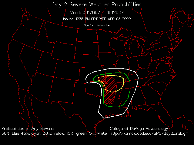
At this time it appears there will be some chance for showers and thunderstorms as early as Thursday evening and into the overnight hours on Thursday. Some of these could be strong thunderstorms – especially over Missouri and Arkansas. The bigger threat comes on Friday. CAPE values on Friday are very high over our region – NAM (computer model) is showing readings over 2000 for the Paducah area. These are significant readings. Lift index values are below -5 to -8. So, instability is not lacking for Friday. Timing of the system is in question, though. If it moves through the area during the morning hours then that might very well lower our severe weather threat. I am going to have to watch the track.
Storm mode – supercells and lines of storms are likely to form Thursday evening and into Friday afternoon.
Storm motion – storms will move east/northeast at 25-30 mph.
Severe weather type – large hail, damaging winds, heavy rain, lightning, and isolated tornadoes are possible.
Thunderstorms are once again possible on Sunday and Monday. It is too early to determine how that event will unfold. We will have to keep eye on the storm track. Further updates on that system will be forthcoming.
Emergency management and officials should pay attention to rapidly changing weather condition Thursday/Friday and listen for later updates and possible watches/warnings. I should have a better grasp of the weather forecast by Wednesday morning.
Also those with river interests should pay close to attention to crest forecasts. Rivers are rising.
Links of interest
Storm Prediction Web-Site
http://www.spc.noaa.gov/
Regional Radar
http://wxweb.meteostar.com/radar/radar_link.shtml?map=SCR_BASE_REFL.gif
Large Regional Radar
http://radar.weather.gov/Conus/full.php
National Weather Service Paducah – watches/warnings
http://www.crh.noaa.gov/pah/
National Weather Service Memphis, Tennessee – watches/warnings
http://www.srh.noaa.gov/meg/
All NWS Sites
http://www.weather.gov/organization.php#maps
Beau Dodson
Meteorological Specialist for the Paducah/McCracken County Office of Emergency Management


