April 11, 2009: Tornado hits Calloway County, KY – Massac County Damage
More damage information from April 10th. Calloway County was hit by a tornado. Right by Joey’s parents. We called and warned them. They didn’t see the tornado. Damage was a couple of miles from them.
PUBLIC INFORMATION STATEMENT
NATIONAL WEATHER SERVICE PADUCAH KY
355 PM CDT SAT APR 11 2009
…DAMAGE SURVEY RESULTS FOR CALLOWAY COUNTY KENTUCKY…
THE FOLLOWING IS A PRELIMINARY DAMAGE ASSESSMENT FOR DAMAGE THAT OCCURRED IN NORTHERN CALLOWAY COUNTY ON FRIDAY APRIL 10TH 2009.
THE DAMAGE PATH INCLUDES A MICROBURST PATH AND WITHIN THAT PATH WAS INCLUDED A BRIEF EF0 TORNADO.
THE TORNADO PATH SURVEYED:
* EVENT TIME – ESTIMATED 1116 AM CDT TO 1118 AM CDT
* EVENT TYPE – EF0 TORNADO
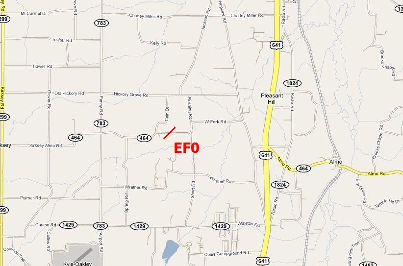
* EVENT LOCATION – BEGAN 3.5 MILES SOUTHWEST OF DEXTER AND LIFTED 3.25 MILES SOUTHWEST OF DEXTER. OR NEAR 2635 HIGHWAY 464
AND LIFTED NEAR 2392 HIGHWAY 464.
* PEAK WIND – 85 MPH
* AVERAGE PATH WIDTH – 75 YARDS
* PATH LENGTH – ONE QUARTER OF A MILE
* INJURIES – NONE
* DAMAGE – SEVERAL HOMES WITH SHINGLES AND SIDING OFF AND SOME LIGHT STRUCTURAL DAMAGE. SEVERAL STORAGE BUILDINGS DESTROYED. DOZENS OF TREES UPROOTED OR BROKEN OFF.
DOWNBURST SURVEYED:
* EVENT TIME – ESTIMATED 1115 AM CDT TO 1120 AM CDT
* EVENT TYPE – MICROBURST
* EVENT LOCATION – BEGAN 4 MILES SOUTHWEST OF DEXTER AND ENDED 2
MILES SOUTHWEST OF DEXTER. THE DAMAGE STARTED AT 2913 HIGHWAY
464 AND ENDED NEAR 531 HICKORY GROVE ROAD.
* PEAK WIND – 70 MPH
* AVERAGE WIDTH – 100 YARDS
* PATH LENGTH – 2 MILES
* INJURIES – NONE
* DAMAGE – DOZENS OF HOUSES WITH SHINGLE AND MINOR SIDING DAMAGE.
MOBILE HOME BLOWN OVER ON ITS SIDE. HALF A DOZEN BARNS WITH ROOF
DAMAGE. THE EF0 TORNADO ALSO OCCURRED IN THE PATH OF THIS
DOWNBURST.
$$

MAP OF THE TORNADOE’S PATH – CALLOWAY COUNTY, KENTUCKY
Radar grabs from the storm – we were watching it when it hit and Joey was on the phone with his parents warning them.

Image from another chaser
.png)
.png)
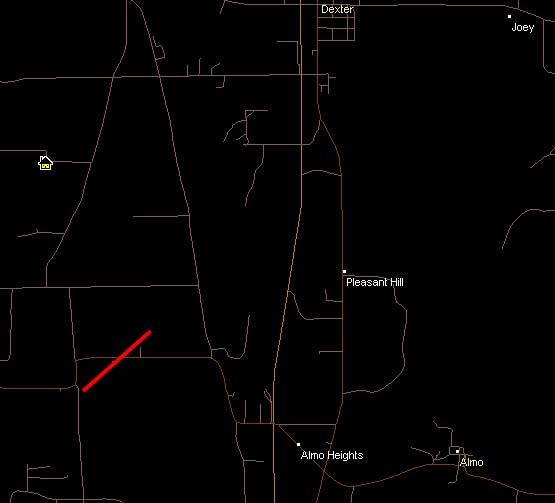
You can see Joey’s house on the radar screen – "Joey"
April 10, 2009
Massac County, Illinois – Approximately 3 miles south/southwest of Round Knob, Illinois. Google map coordinates below each image.
Damage photos in order from southwest to northeast – the photos of the home with the trampoline in the tree is northeast of these damage areas.
Microsoft Streets and Trip – Map – the line indicates the approximate area of the photographs below.

The damage continues on to the northeast of this path and southwest
Photographs I took in Massac County, Illinois

Debris in a tree – approximate location is 37.19774 N and – 88.75793W

Garage door damaged – Debris in a tree – approximate location is 37.19774 N and -88.75793W

Trailer damaged – approximate location is 37.20815N and -88.74418

Garage destroyed – debris from barn was thrown hundreds of feet to the east/northeast (also to
the west/southwest of this location there was a field with debris – tin – and no visible barn
nearby. Location of this barn is approximately 37.20876 and -88.73898

Location of this debris/barn is approximately 37.20876 and -88.73898

Location of this barn is approximately 37.20876 and -88.73898

The squall line as it approaches the region

The Massac County Storm moving across the Ohio River – damage was occurring

Storm near Franklin School and Round Knob – Massac County
Here is the tornado track – Joey’s parents house (upper right corner)

