February 6th, 2008
PUBLIC INFORMATION STATEMENT
NATIONAL WEATHER SERVICE PADUCAH KY
400 PM CST WED FEB 6 2008
…STORM DAMAGE SURVEY RESULTS FOR A PORTION OF CALLOWAY COUNTY
KENTUCKY ON TUESDAY FEB 5…
THE FOLLOWING IS A FINAL DAMAGE ASSESSMENT WHICH OCCURRED NEAR
POTTERTOWN AND BOATWRIGHT KENTUCKY.
* EVENT DATE: TUESDAY, FEBRUARY 5, 2008
* EVENT TIME: 625 PM CST TO 630 PM CST
* EVENT TYPE: TORNADO
* EVENT LOCATION: BEGAN APPROXIMATELY 1.8 MILES NORTHEAST OF
POTTERTOWN KENTUCKY AND ENDING 1.5 MILES NORTHWEST OF BOATWRIGHT
KENTUCKY.
* PEAK WIND: 94 MPH
* RATING: EF-1
* DAMAGE DIMENSIONS: APPROXIMATELY 1.2 MILES IN LENGTH AND
AVERAGING 90 YARDS WIDE…WITH MAXIMUM WIDTH 150 YARDS.
* INJURIES: NONE
* FATALITIES: NONE
* DISCUSSION/DAMAGE: ONE HOME WITH SHINGLE AND SOFFETT DAMAGE. ONE
HOME WITH 2 LARGE WINDOWS BLOWN OUT WITH SIGNIFICANT INTERIOR
DAMAGE. WINDS ENTERED THE ATTIC THEN BLEW OUT THE INTERIOR
CEILINGS…THEN EXITED THE HOME THROUGH THE BASEMENT WINDOWS.
SPORADIC TREE DAMAGE ALONG THE PATH LENGTH.
Topics:
Uncategorized |
Comments Off on Feb 6, 2008: Calloway County Tornado – East of Murray
February 6th, 2008
PUBLIC INFORMATION STATEMENT
NATIONAL WEATHER SERVICE HUNTSVILLE AL
635 PM CST WED FEB 6 2008
…PRELIMINARY STORM SURVEY INFORMATION FROM JACKSON COUNTY
ALABAMA…
A PRELIMINARY STORM SURVEY OF THE DAMAGE INCURRED ACROSS JACKSON
COUNTY ALABAMA HAS BEEN COMPLETED BY NATIONAL WEATHER SERVICE AND
JACKSON COUNTY EMERGENCY MANAGEMENT PERSONNEL. INITIAL FINDINGS ARE
AS FOLLOWS:
* LOCATION: THE MOST SIGNIFICANT DAMAGE OCCURRED NEAR THE
INTERSECTION OF COUNTY ROAD 60 AND 177 BETWEEN THE ROSALIE AND
PISGAH COMMUNITIES IN EASTERN JACKSON COUNTY.
* PATH LENGTH: STILL BEING DETERMINED
* MAXIMUM PATH WIDTH: 3/8 MILE
* ESTIMATED PEAK WIND: 180 MPH
* PRELIMINARY RATING: EF-4
* FATALITIES: 1
* INJURIES: UNKNOWN
ADDITIONAL INFORMATION INCLUDING A MORE COMPLETE SUMMARY WILL BE
MADE AVAILABLE LATER TONIGHT.
Topics:
Uncategorized |
Comments Off on Feb 6, 2008: EF4 Jackson County, Alabama
February 6th, 2008
The Jackson, Tennessee tornado has been rated EF4. This is the deadliest outbreak for the State of Tennessee since 1933.
Topics:
Uncategorized |
Comments Off on Feb 6, 2008: EF4 Jackson, Tennessee
February 6th, 2008
Early reports are at least 78 tornadoes. Numerous reports of major damage across portions of Arkansas, Missouri, Kentucky, Illinois, Tennessee, and Mississippi. At least 54 dead and over 200 injured. Jackson, Tennessee and Memphis, Tennessee have been hit very hard. Portions of Kentucky have also been hit by a tornado. At least three dead in Kentucky. It appears the worst damage area is from south of Murray and then northeast through Kentucky Lake and into Central Kentucky.
Joey’s sister road at the storm in the basement of the hospital in Jackson, TN. They were in shelter for several hours as multiple tornadic cells moved through. She is OK but reports a lot of damage.
Early reports are that some towns have substantial damage indicated at least EF3 strength and possible EF4 damage.
The map below is from 2 a.m. A lot more tornadoes will still be added to this. It does give you an idea on the extent of this outbreak. This was the first high risk that I have EVER seen in the month of February for the Paducah Area. This is also the largest February outbreak I have ever seen. I hope spring isn’t going to be like this.
Meanwhile, we are under a winter storm warning up here in Canada.
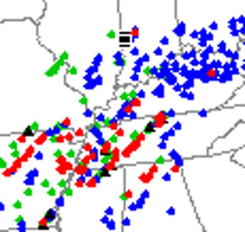
Red Dots Are Tornadoes…
Topics:
Uncategorized |
Comments Off on Feb 6, 2008: NIGHT OF TWISTERS ACROSS THE OHIO AND TN VALLEY